El Niño settles in |
| By Amber Friedrichsen, Associate Editor |
|
|
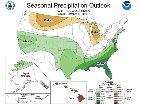
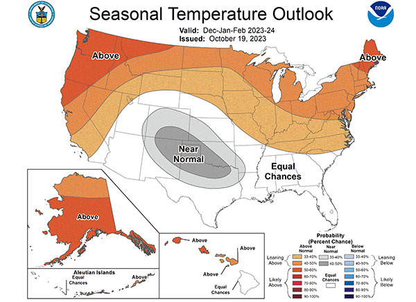
 Northern regions are expected to experience warmer temperatures this winter while southeastern states can anticipate higher rainfall, according to the U.S. Winter Outlook from the National Oceanic Atmospheric Administration (NOAA). The latter trend promises drought relief in some regions, which may impact growing conditions next year. Brad Pugh, the operational drought lead with NOAA, says about one-third of the United States is currently in a drought; however, recent rainfall seemed to ease the dryness in some parts of the country to an extent, and El Niño is projected to have a similar effect. “El Niño, with its enhanced precipitation, is expected to provide drought relief to the southern U.S. during the next few months,” Pugh asserts. Back in June, the NOAA issued an advisory to announce that El Niño conditions were present and would persist through the year. Forecasters predicted the weather patterns associated with El Niño would be slow to arrive in the summer but strengthen into the fall and the winter. In fact, the organization reports South American fishermen originally coined the term “El Niño de Navidad” in the 1600s because the weather event tended to peak in December. El Niño is caused by the warmest phase of the El Niño-Southern Oscillation (ENSO), or the cycle of warm and cold surface temperatures of the central and eastern Pacific Ocean. These warm waters push the Pacific jet stream south, instigating warmer and wetter weather in the Southeast and Gulf Coast. El Niños are typically blamed for more flooding events in these areas, as well as more Pacific hurricanes, like the tropical storm that hit Southern California in August. Northern and Midwestern states have also historically experienced warmer temperatures during previous El Niños, but these regions generally don’t see as much of a rise in rainfall.   From December through February, NOAA forecasters expect the greatest wetter-than-average conditions in the Southeast, Gulf Coast, southern Plains, and lower mid-Atlantic regions, as well as parts of California. On the other hand, drier-than-average areas include the central Great Lakes region and the northern Rockies. The Pacific Northwest, northern New England, and Alaska are pegged with the greatest warmer-than-average temperatures this winter, although warmer temperatures are projected across the entire northern tier of the continental U.S. Temperatures in the southern Plains and south-central Rockies will likely be near normal. Sarah Kapnick, NOAA chief scientist, notes these weather outlooks provide guidance for several industries and economic sectors, including agriculture. Although some producers may receive drought relief this winter, weather outlook data and El Niño updates will continue to paint a picture for forage production in the upcoming growing season. |
